GIS Maps

In this map, the number of people with asthma in 2011 is shown in the United States, compared to the total population of each state. This map displays that the number of people with asthma is much higher in the Northeast of the United States. In the West coast, the percent of people who are embodied with asthma is lower compared to the East. From this, there seems to be some sort of relationship between the East coast and their higher population count for people with asthma.
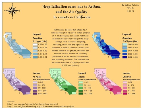
This map demonstrates the air quality by county in California and the amount of hospitalizations of asthma patients in 2010. The three maps displayed on the bottom of the map show the amount of adults, children, and the overall total. The two upper maps show the air quality based in their standard rate by time intervals 1 and 8 hours. As seen on the maps the highest number of hospitalizations are in southern California, specifically Los Angeles has the highest number of hospitalizations. The air quality maps demonstrates high amounts of air pollution in southern California. This confirms that Air Quality is a factor in asthma cases.
